
New geological map reveals a new story about Greenland’s largest intrusive complex

Published 19-06-2026

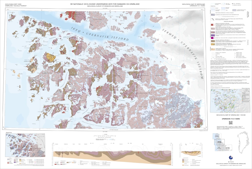
GEUS has published a new geological map of the Upernavik region in north-west Greenland at a scale of 1:100,000. The release is the first of two new map sheets from the region (UPERNAVIK and INNERIT) and provides an updated view of one of Greenland’s largest magmatic complexes.

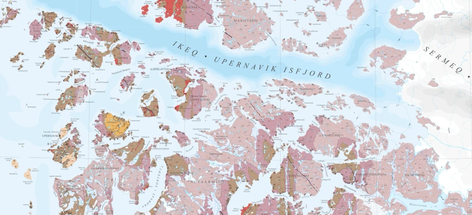
Excerpt from the new geological map of the Upernavik region. The map combines decades of geological observations with new analytical data and modern mapping techniques, resulting in a significantly improved understanding of the geological evolution of the area. A link to the full map can be found at the bottom of this page or in the box to the right. Map: GEUS

The UPERNAVIK map sheet (72°30′–73°N) covers the northern part of the Upernavik region and encompasses a complex coastal landscape of fjords and islands. The map documents the architecture of the Paleoproterozoic Rinkian Orogen – an ancient mountain belt that formed along the margin of the Archean Rae Craton approximately 1.9 billion years ago.

“The map provides an entirely new and much more detailed picture of how one of Greenland’s largest intrusive complexes was formed and subsequently deformed,” explains Thomas Find Kokfelt, senior researcher at GEUS.
One of Greenland’s largest magmatic complexes

The geology of the region is dominated by the Prøven Igneous Complex (PIC) – one of the largest intrusive complexes in Greenland. New geological and geochemical data show that the complex formed within a subduction-related magmatic system along the margin of the ancient continent – an interpretation that challenges previous views of the geological evolution of the region.

The new map demonstrates that the complex forms a large sheet-like intrusion emplaced into metasedimentary rocks and subsequently deformed and transported within a fold-and-thrust system during the Rinkian mountain-building event.

According to Thomas Find Kokfelt, the results indicate that most of the deformation occurred after emplacement of the intrusion, providing new insights into the relationship between magmatism and orogenesis.

New mapping using modern methods

The map is based on a systematic compilation of historical field maps produced by the Geological Survey of Greenland (GGU) together with new data collected by GEUS in close collaboration with researchers from Durham University (UK). This collaboration has, over several years, contributed significantly to our understanding of the architecture and tectonic evolution of the northern Rinkian Orogen.

The work combines classical field geology with modern techniques, including:

  • high-resolution helicopter-based photogrammetry
  • digital terrain models
  • interpretation of aerial photographs and satellite imagery
  • new structural measurements collected in the field

These methods have made it possible to map even the most inaccessible parts of the deeply dissected fjord-and-island coastline. In particular, three-dimensional models have been crucial for understanding complex structures such as folds, faults and intrusive contacts.

New data change the geological understanding

The mapping is integrated with new geochemical analyses and geochronological data, showing that the Prøven Complex formed through multiple intrusive phases between approximately 1895 and 1850 million years ago.

Previously, the complex was primarily interpreted as having formed in a passive continental-margin setting. New geochemical data instead demonstrate that the rocks were generated within a subduction-related magmatic system along the continental margin – a geological environment comparable to the granitic batholiths found today along the Andes.

The younger intrusive phases show a geochemical evolution towards more iron-rich granites, probably reflecting changes in magma sources through time. The analyses also demonstrate that the region was later subjected to high temperatures and pressures, reflecting deep burial and deformation during the subsequent mountain-building event.

A new perspective on mineral potential

The new understanding of the Prøven Complex also provides a new perspective on the mineral potential of the region, explains Thomas Find Kokfelt:

“The new geological model changes the types of mineralisation systems that can be expected in the area. By linking the Prøven Complex to a subduction-related magmatic system, we identify geological processes that globally are associated with several types of economically important mineral deposits.”

Although no major mineral deposits are currently known from the Prøven Complex, the new geological interpretation provides a significantly improved framework for assessing the mineral potential of the region. The area already hosts several small graphite occurrences.

The new map and its associated geological datasets therefore provide an important foundation for future mineral exploration and geological research in north-west Greenland.

BOX: Built on decades of geological work

The map builds upon extensive fieldwork carried out by GGU during the 1960s and 1970s. In particular, geologists Chris Pulvertaft, Jan Escher and Ole Stecher played central roles in the early geological mapping of the region and established the geological foundation upon which the new work builds.

Their original field maps and notes have now been digitised and reinterpreted in combination with recent field campaigns, geochemical analyses and modern mapping techniques undertaken by GEUS and its collaborators.

The result is the most detailed and geologically up-to-date map of the Upernavik region produced to date, and a new geological reference for the northern part of the Rinkian Orogen.

UPERNAVIK

Citation

Kokfelt, T.F., Sørensen, E.V., Grocott, J., Sleath, P.R., McCaffrey, K.W. & Rosa, D. (2026):

Geological map of Greenland 1:100 000: Upernavik 72 V.1 Nord.

Copenhagen: Geological Survey of Denmark and Greenland.

https://doi.org/10.22008/FK2/BEAREO

Technical Information

Editorial handling: Pierpaolo Guarnieri

Data sources:

  • Historical GGU maps and field data (1960s–1970s)
  • GEUS field campaigns (2017–2018)
  • Aerial photographs and satellite imagery
  • Photogrammetric models and digital elevation models
Thomas Find Kokfelt
Senior Researcher
Mapping and Mineral Resources
Fie Krøyer Dahl
Editor
Press and Communication